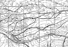
Geomap® Company has made some additions to the Oklahoma Woodford map service. A new structural horizon Map O-36, covering portions of Oklahoma, Logan, Kingfisher and Canadian counties has been added to the service. O-36 is mapped on the Top Woodford at 1"=4000' scale.
A "Horizontal Springer Oil Play" map has also been added. This new addition is designed to show the historical distribution of Springer age oil and gas production in Oklahoma. The approximate limits of the Springer oil window are highlighted. Colored stars are used to show the locations of horizontal Springer oil discoveries. Active operators are distinguished by the color of the stars. This combination of elements should provide a quick reference showing the relationship of play development to historical Springer production, which operators are active in the play, the area each operator is working and alternatives for expanding the play.
The Tuscaloosa Marine Shale, or TMS, is the middle member of the Tuscaloosa Formation.
It was deposited as a transgressive shale unit which is sandwiched between the sandier
Lower and Upper Tuscaloosa.
The target of the TMS play is its
basal resistive zone. In southwest Mississippi and Louisiana's Florida Parishes the
zone varies in thickness between 90' and 150' at a resistivity of 8 ohms.
It is an oily, calcareous shale with thinly bedded siltstones.
Initial evaluation and production was conducted by Sun, Callon, and Texas Pacific in the 1970's.
The first horizontals were drilled by Worldwide and Petroquest in 1999 and 2000. Encore entered the
play in 2008, but experienced low production rates. The current effort has yielded much greater IP's
due to improved completion techniques and longer laterals. These latest operators include Encana, Goodrich, and Devon. EOG and Indigo II are attempting to extend the play to central and west Louisiana.
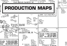
GEOMAP's TMS map service isopachs the basal resistive zone, and maps the structure of the Lower Tuscaloosa. Well locations and completions are tracked on an activity map, and four cross-sections help delineate the zone.
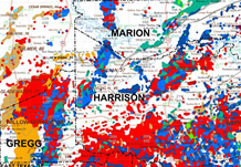
GEOMAP® Company is introducing their Mississippian Lime Map Service. This service focuses on the highly productive horizontal Mississippian Lime Play along the Kansas/Oklahoma border. Components of this service include structure maps, production maps, and play maps that provide a quick reference showing the relationship of the developing play to the historical Mississippian production, what operators are most active in the play, the area each operator is working, and alternatives for play expansion